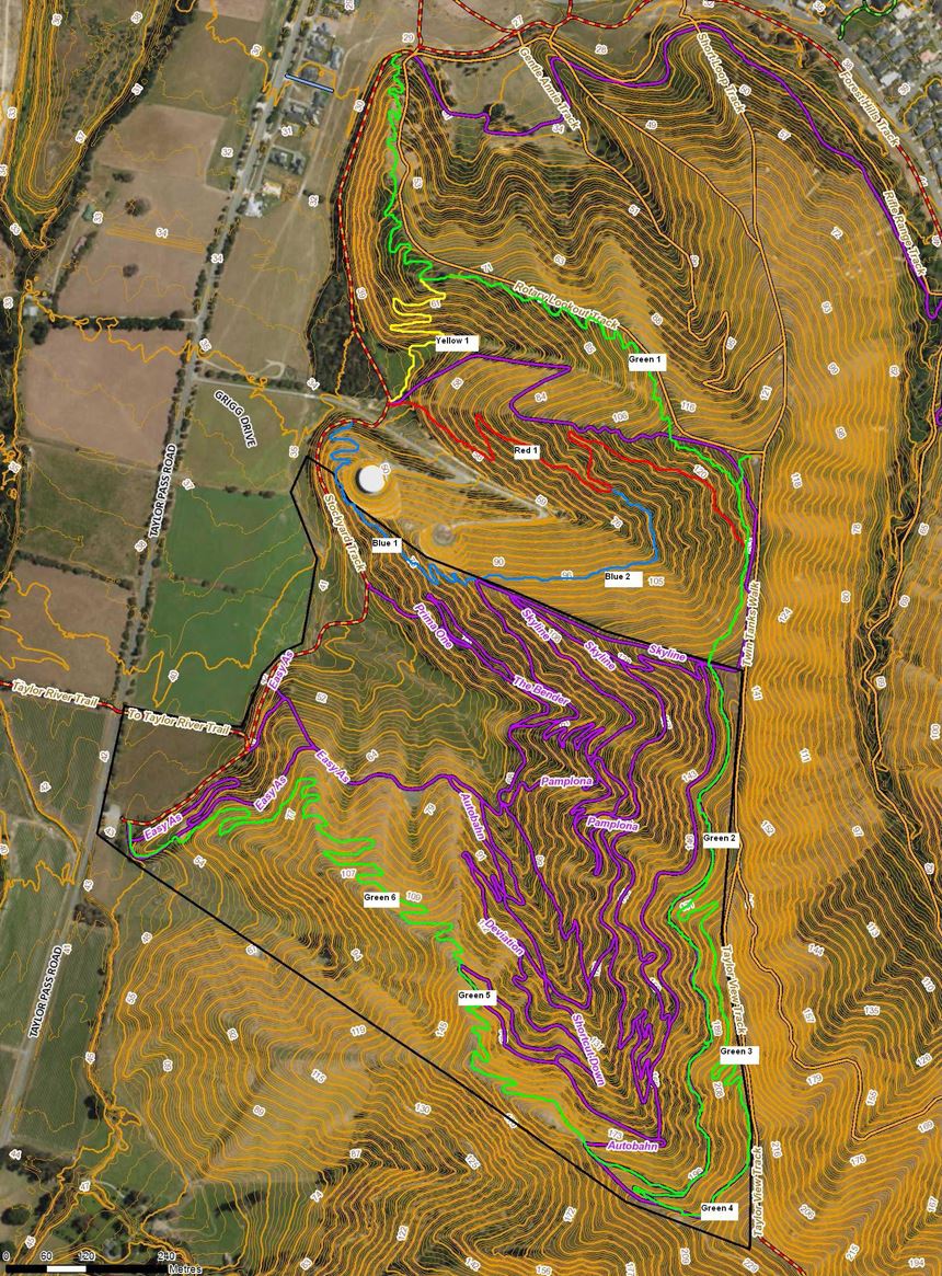
1. MTB Boundary Loop Trail (ring trail). Map key bright green
This option would provide a grade 2/3 loop around the workable perimeter of the mountainbike area, allowing a higher level of recreational user access to the Rotary Lookout and right around the mountainbike trail system. Multiple trail options would then present for loop trail riders who might want to drop into the established trail system. This build would require new sections of trail at the northern and southern ends, a small section of new trail off the highest point linking back to Autobahn, and utilises the top traverse of Autobahn as the main western route. Individual components of this loop are as follows:
Green 1 This section of the loop would be new, and would start climbing immediately south of the existing cattle stop below the Rotary Lookout Track. It would climb at an average gradient of 6.7% (1:15) through a natural ridge of sparse wattle, tending to pine after the first saddle on the south side of the fence line. This gradient would be maintained into the section of clear pasture, and onto the young pine at the top of the ridge leading to the Rotary Lookout. Two fence crossings would be required here. A short link would be required to access the Rotary Lookout site, while the main track contours away in the southern direction above the on-hold ‘Pete’s Track’ project, across the top of the next pasture section before linking with the existing top traverse of the Autobahn. New Trail Length: 2km Nominal Trail Width: 1.2m
Green 2 This section of the loop would use the top traverse of Autobahn. The gradient of this section of trail is consistent with a grade 2/3 loop track and would take riders to the south-western corner of the Farm Park. While this section of trail will work well for the loop, it would benefit from some reverse gradient and outslope retrofit, to improve sustainability and user enjoyment.
Green 3 This section of the loop provides access to/from the highest point of the mountainbike trail system, linking back into the Autobahn traverse and providing access to the Mt Vernon Traverse Track from a northerly direction. New Trail Length: 0.5km Nominal Trail Width: 1.2m
Green 4 The existing Connector to Mt Vernon Traverse track would be retained to maintain access from the south-eastern corner of the Farm Park to the high point, and to the Mt Vernon Traverse Track.
Green 5 The existing section of Autobahn from the Connector to Mt Vernon Traverse intersection, west to the first major corner on Autobahn would form part of the loop. From this corner, a new track would be built following open contours and bounded by the southern boundary fence. This new section of the loop would link in with the last part of the top section of Squawking Magpie. Room is tight at this section of the available land, and a small section of Squawking Magpie may need to be re-routed to allow the loop trail to be worked in. New Trail Length: 0.4km Nominal Trail Width: 1.2m
Green 6 This new section of trail would follow natural contours in and out of three natural valleys and ridges to connect up with Easy As right at the western corner of the Farm Park, as close as possible to the Taylor Pass Road carpark. Constructing this new section of the loop track will also allow remediation of erosion problems caused by the abandoned downhill track construction. New Trail Length: 1.6km Nominal Trail Width: 1.2m
2. Pete’s Track Remediation/Rebuild. Map key bright red
The ‘stop work’ Pete’s Track could be reactivated, but within tight boundaries of average and maximum sustainable gradient given its predominantly loess substrate. The work already done on Pete’s Track should be remediated as much as possible, by pulling all side caste back onto the natural sideslope of the hill, and track rolling to compact and stabilise. The proposed new Pete’s Track should be at an average gradient of 10% or less and constructed along the natural contours of this pine block, utilising turning points on the north side close to the pine boundary (and natural ridge), and on the south side at the available flatter areas of the contour profile. Constructing this track from scratch would allow the opportunity to build in a greater level of variety to the Farm Park, and a descending ‘flow’ type trail with rolling features could be a great option. Careful consideration would need to be given to the exit point of this trail, as the natural fall of the land to the Stockyard Track is very low and wet, made worse as a current grazing area for cattle. New Trail Length: 1.1km Nominal Trail Width: 1.0m
3. Stockyard Link. Map key bright yellow The proposed new trails open up several opportunities to link with existing tracks, creating interesting small loops. The yellow link shown is a good example of this, providing an easily constructed two-way link between the existing Stockyard Track and the proposed new Loop Track. As with Pete’s Track, the exit point for this link would be in a similar location, and would need to be carefully considered. New Trail Length: 0.35km Nominal Trail Width: 1.2m
4. Water Reservoir Link. Map key blue This inner link would provide a climbing option to the Skyline Trail from the Stockyard Track at a mid point.
Blue 1 Good opportunity exists to utilise the scrappy wattle forest on the western side of the first water reservoir, to access some ideal contours and climb/link to the Skyline Trail. Remnants of an old, disused trail in this area are clearly visible but would not be utilised for this link, being too steep.
Blue 2 This link could very easily sidle across the open land and into the mid-point of Pete’s Track, providing another interesting inner loop in both directions. New Trail Length: 1.1km Nominal Trail Width: 1.2m